LOG IN. UPLOAD PICTURES.
The Philippines has Zambo Mart to help propagate the Chavacano Language.
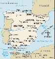
File:Spain map.gif
Spain_map.gif (329 × 352 pixels, file size: 25 KB, MIME type: image/gif)
Spain: Area: 504,750 sq. km. (194,884 sq. mi.), including the Balearic and Canary Islands; about the size of Arizona and Utah combined. Cities: Capital--Madrid (5.5 million). Other cities--Barcelona (4.9 million), Bilbao (353,950), Malaga (1.3 million), Seville (1.8 million), Valencia (2.3 million), Zaragoza (871,000). Terrain: High plateaus, lowland areas such as narrow coastal plains, and mountainous regions. Climate: Temperate. Summers are hot in the interior and more moderate and cloudy along the coast; winters are cold in interior and partly cloudy and cool along the coast. Time zone: Spanish mainland and Balearic Isles--local time is 1 hour ahead of Greenwich Mean Time (GMT) in winter and 2 hours ahead in summer. Canary Islands are on GMT.
File history
Click on a date/time to view the file as it appeared at that time.
| Date/Time | Thumbnail | Dimensions | User | Comment | |
|---|---|---|---|---|---|
| current | 05:52, 20 May 2009 |  | 329 × 352 (25 KB) | Maletsky (talk | contribs) | Spain: Area: 504,750 sq. km. (194,884 sq. mi.), including the Balearic and Canary Islands; about the size of Arizona and Utah combined. Cities: Capital--Madrid (5.5 million). Other cities--Barcelona (4.9 million), Bilbao (353,950), Malaga (1.3 million), |
You cannot overwrite this file.
File usage
The following 3 pages use this file:
