LOG IN. UPLOAD PICTURES.
The Philippines has Zambo Mart to help propagate the Chavacano Language.
Difference between revisions of "Tuvalu"
| Line 70: | Line 70: | ||
From the 1960s, racial tension and rivalries over employment emerged between Gilbertese and Ellice Islanders. Ellice Islanders’ demands for secession resulted in a referendum in 1974, transition to separate colonial status between October 1975 and January 1976, and independence as Tuvalu in 1978. After independence the main priorities were to establish the infrastructure for a separate, if small, nation, and to seek foreign assistance to match political independence with economic viability. | From the 1960s, racial tension and rivalries over employment emerged between Gilbertese and Ellice Islanders. Ellice Islanders’ demands for secession resulted in a referendum in 1974, transition to separate colonial status between October 1975 and January 1976, and independence as Tuvalu in 1978. After independence the main priorities were to establish the infrastructure for a separate, if small, nation, and to seek foreign assistance to match political independence with economic viability. | ||
==Tuvaluan Legends== | |||
>Funafuti | |||
Legends of the Islands Names: Funafuti | |||
According to legend Funafuti people originated from Samoa, arriving by canoe. The founding ancestors were Telematua and his two wives Futi (meaning banana) and Tupu (meaning "holy" or "abundant"). | |||
The island is named after the wife Futi, while funa is a feminine prefix. | |||
The travellers first settled on Funafala islet before | |||
shifting to Fongafale, where the main village is still situated. | |||
Later, leaving Futi on Funafuti, Telematua, searching for a land of greater fertility and where fresh water was more plentiful, discovered Vaitupu. There he left Tupu and henceforth he divided his time between the two islands. | |||
[[File:Geic_land_of_bananas.jpg ]] | |||
'''1972 Gilbert and Ellice Islands stamp''' | |||
[[File:Spacefunafala1.jpg]] | |||
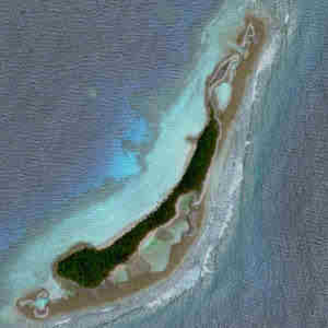
'''Funafala, Tefota and Telele''' | |||
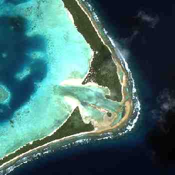
Funafuti is the capital of Tuvalu. It is a true atoll that consists of 30 islands, or motu, as called by the Tuvaluans, surrounding a lagoon 20 kilometres north to south by 11 kilometres east to west. The total land area consists of only 2.79 sq. kilometres. | |||
Funafuti is often described as looking like a human head when viewed from space, with most of the land area appearing at the "back" of the head, or the eastern side of the lagoon. The lagoon at the narrow "neck" area is very shallow, and the surrounding islets are known for their unspoiled beauty and sandy beaches. | |||
In 1897, Sir T. W. Edgeworth David, a Welsh-born Australian geologist drilled to a depth of 200 metres at Funafuti Atoll in an effort to verify Darwin's theory of the formation of coral atolls. Whereas his results supported Darwin's ideas, they were short of absolute proof. The main bore hole, called David's Drill, still can be seen today. | |||
The largest island of Funafuti is Fogafale on the eastern side of the atoll. It is permanently connected to the island directly to the north, Tegako, by a concrete causeway, initially built by the Americans in during World War II. The runway on Fogafale was also built buy the Americans during the war. War relics can still be seen around the lagoon and other parts of the island. There is a burried bunker on Tepuka, which was an American wartime communications outpost. | |||
The deep sea warf on the lagoon side of north Fogafale was completed on October 28, 1981. Before that, cargo to Funafuti had to be unloaded via boat or barge. | |||
There is a shipwreck on the lagoon side just north of the warf, the Van Camp No. 1, which was blown ashore by Hurricane Bebe in 1972. | |||
One of the smallest islands, Tepuka Sailivili, had all its vegetation and most of its sand washed away by Cyclone Meli in 1997. | |||
The lagoon, which has several deep natural passages to the ocean, is known a Te Namo by the Tuvaluans. A conservation area called Kogatapu groups six of the uninhabited islands on the western side. | |||
There are nine main villages on Funafuti, seven on Fogafale, and one each on Amatuku and Funafala. However, Fogafale is so densely populated it appears as one big sprawl. Most of the government offices are located in Vaiaku, including the main government building, the largest structure on the island. The population of Funafuti is 4,492 according to the 2002 census. | |||
The largest man-made structure on Funafuti is the Tuvalu Government Building in Vaiaku, completed in 2004. | |||
[[File:Tuvalu_tefota.jpg]] | |||
''Tefota, 2005. (c) Brian Cannon'' | |||
[[File:Tuvalu_falefatu.jpg]] | |||
''Falefatu'' | |||
[[File:Tuvalu_funafuti_davids_drill.jpg]] | |||
''David's Drill, Fogafale, 2005. (c) Brian Cannon'' | |||
'''The motu names are as follows:''' | |||
*Amatuku | |||
This island is about 1 kilometer long and a maximum 200 meters wide. Being the home of the Tuvalu Maritime Training Institute (TMTI), it has very favourable conditions; an independent power supply of that on Fogafale, telephone communications, daily access to the facilities on Fongafale, and a pleasant well vegetated setting. However, as with Fogafale, there is water rationing at times. The maximum population is about 65. | |||
Tuvaluan men are trained at the TMTI to become merchant seamen, to enable them to seek employment aboard foreign vessels. The school opened in 1979. Money sent home by seamen is a major source of revenue for Tuvalu. Approximately 43% of the male population of working age in Tuvalu are employed as seafarers. | |||
There are approximately 12 TMTI professional and support staff plus family members. The Institute accomodates up to 40 trainees per session, which lasts about 12 months. | |||
The oldest building in Tuvalu is on Amatuku, a thatched roof house with original coral rock walls. It was built in 1904 by the London Missionary Society as a school, and now is a heritage site. | |||
Construction of a renewable energy project began in early 2007 on Amatuku. It was instigated by Alofa Tuvalu, a French/Tuvaluan Non-Government Organization (NGO). Biogas digester units were to be installed, using human and pig waste to great power. Further plans include copra biodiesel, gasification from organic waste, a small windmill, thermal solar, PV systems, solar streetlights and compost | |||
[[File:Amatuku_biodigester.jpg]] | |||
''Installing biodigesters. (c) Christopher Horner, 2007'' | |||
[[File:Amatuku_tuvalu_view.jpg]] | |||
''Swimming off Amatuku, 2007. (c) Lomi Paeniu'' | |||
Avalau | |||
Falaoigo | |||
Falefatu | |||
Fatato ...more | |||
Fogafale | |||
Fuafatu | |||
Fuagea | |||
Fualefeke | |||
Fualopa | |||
Funafala | |||
Funagogo (or Papaelise or Papa Elise) ...more | |||
Funamanu | |||
Luamotu | |||
Mateiko | |||
Motugie | |||
Motuloa | |||
Mulitefala | |||
Paava | |||
Teafuafou | |||
Teafualiku | |||
Tefala | |||
Tefota | |||
Telele | |||
Tegako (now joined with Fogafale) | |||
Tegasu | |||
Tepuka | |||
Tepuka Savilivili (vegetation washed away) | |||
Tutaga | |||
Vasafua | |||
==Disclaimer== | ==Disclaimer== | ||
{{disclaimer countries}} | {{disclaimer countries}} | ||
[[category:countries]] | [[category:countries]] | ||
Revision as of 07:41, 28 April 2015
Official name Tuvalu
Form of government constitutional monarchy with one legislative house (Parliament [15])
Head of state British Monarch: Queen Elizabeth II, represented by Governor-General: Sir Iakoba Taeia Italeli
Head of government Prime Minister: Enele Sopoaga
Capital government offices are at Vaiaku, Fongafale islet, of Funafuti atoll
Official language none
Official religion none
Monetary unit Tuvaluan dollar
Population (2013 est.) 11,300COLLAPSE
Total area (sq mi) 9.9
Total area (sq km) 25.6
Urban-rural population
- Urban: (2010) 50.4%
- Rural: (2010) 49.6%
Life expectancy at birth
- Male: (2012) 62.7 years
- Female: (2012) 67.3 years
GNI per capita (U.S.$) (2013) 6,630
Background of Tuvalu
Tuvalu, formerly Ellice Islands, country in the west-central Pacific Ocean. It is composed of nine small coral islands scattered in a chain lying approximately northwest to southeast over a distance of some 420 miles (676 km). The capital is Funafuti Atoll; most government offices are located in the village of Vaiaku, Fongafale islet, a constituent part of Funafuti Atoll. With colonial Kiribati, Tuvalu formed the unit known as Gilbert and Ellice Islands Colony.
Geography of Tuvalu
Land
The group includes both atolls and reef islands. The atolls—Nanumea, Nui, Nukufetau, Funafuti, and Nukulaelae—have islets encircling a shallow lagoon; the reef islands—Nanumanga, Niutao, Vaitupu, and Niulakita—are compact with a fringing reef. The islands are low-lying, most being 13 to 16 feet (4 to 5 metres) above sea level. There are no rivers; rain catchment and wells provide the only fresh water. Rainfall averages 100 inches (2,500 mm) in the north and 125 inches (3,175 mm) in the south. The prevailing winds are southeast trades; westerly storms occur from November to February. Daytime temperatures range from 80 to 85 °F (27 to 29 °C).
Because the soils are porous, agriculture is limited. Coconut palms thrive, and breadfruit trees, pandanus, taro, and bananas are grown. Pigs and chickens are raised, and seabirds, fish, and shellfish are caught for food. The islands increasingly depend on imported food.
Demography of Tuvalu
People
The Tuvaluans are Polynesian, and their language, Tuvaluan, is closely related to Samoan. Nui, however, was heavily settled in prehistoric times by Micronesians from the Gilbert Islands (now Kiribati). English is taught in the schools and widely used. The vast majority of the population belongs to the Church of Tuvalu (the former Ellice Islands Protestant Church).
Although most people live on the outer islands in extended family households clustered into villages, about one-third of the population lives on Funafuti, the centre of government and commerce. Population growth has been slowed by family planning; life expectancy at birth is about 60 years. About 10 percent of the population lives overseas, either pursuing education, working in the Nauru phosphate industry, or working on merchant ships.
Economy of Tuvalu
Most Tuvaluans are subsistence farmers and are aided by remittances from relatives working overseas. A small quantity of copra is produced for export, the sale of stamps accounts for modest earnings, and fees are collected from foreign fishing fleets, but the country depends heavily on foreign aid. It imports most of its food, fuel, and manufactured goods. Retailing is handled by community-based cooperative societies. Tuvalu uses Australian currency but also issues its own coinage. There is a single bank, a joint government-commercial venture.
Tuvalu has air links with Kiribati and Fiji; for international shipping, it depends on irregular regional services. Seaplanes have been used for interisland travel, but generally the outer islands depend on a single government vessel. Motorcycles are common on Funafuti, but there are few automobiles.
Government and Society of Tuvalu
Tuvalu is a constitutional monarchy within the Commonwealth, with the British monarch (through a governor-general) as head of state. The government is a parliamentary democracy with a unicameral legislature elected by universal adult suffrage. There are no political parties: the prime minister is chosen by and from the legislature. Tuvalu is a member of the South Pacific Forum.
The government provides universal primary education and, under a joint arrangement with the Church of Tuvalu, secondary education to school certificate level for selected pupils. A few are sent overseas for further education and training. Medical facilities are centralized on Funafuti, but all other islands have clinics with trained medical staff.
Culture Life of Tuvalu
The Tuvaluan lifestyle has been Westernized to an extent, but Western-style amenities are few. Only Funafuti has a regular electricity supply; the government publishes a brief news sheet, but there is no newspaper; a few motion pictures are shown; satellite television service is available only by subscription; and there is only a single radio station. Most Tuvaluans live in villages of a few hundred people, tend their gardens, and fish from handcrafted canoes. Traditional music and dancing still enjoy a strong following, along with Western forms. Volleyball, football (soccer), and cricket are popular. Tuvaluan life, despite modernization, still rests on a firm traditional base that emphasizes the importance of community consensus and identity.
History of Tuvalu
The first settlers were from Samoa and probably arrived in the 14th century ad. Smaller numbers subsequently arrived from Tonga, the northern Cook Islands, Rotuma, and the Gilbert Islands. Niulakita, the smallest and southernmost island, was uninhabited before European contact; the other islands were settled by the 18th century, giving rise to the name Tuvalu, or “Cluster of Eight.”
Europeans first discovered the islands in the 16th century through the voyages of Álvaro de Mendaña de Neira, but it was only from the 1820s, with visits by whalers and traders, that they were reliably placed on European charts. In 1863 labour recruiters from Peru kidnapped some 400 people, mostly from Nukulaelae and Funafuti, reducing the population of the group to less than 2,500. A few were later recruited for plantations in Queensland, Australia, as well as in Fiji, Samoa, and Hawaii. Concern over labour recruiting and a desire for protection helps to explain the enthusiastic response to Samoan pastors of the London Missionary Society who arrived in the 1860s. By 1900, Protestant Christianity was firmly established.
With imperial expansion the group, then known as the Ellice Islands, became a British protectorate in 1892 and part of the Gilbert and Ellice Islands Colony in 1916. There was a gradual expansion of government services, but most administration was through island governments supervised by a single district officer based in Funafuti. Ellice Islanders sought education and employment at the colonial capital in the Gilbert group or in the phosphate industry at Banaba or Nauru. During World War II, U.S. forces were based on Nanumea, Nukufetau, and Funafuti, but hostilities did not reach the group.
From the 1960s, racial tension and rivalries over employment emerged between Gilbertese and Ellice Islanders. Ellice Islanders’ demands for secession resulted in a referendum in 1974, transition to separate colonial status between October 1975 and January 1976, and independence as Tuvalu in 1978. After independence the main priorities were to establish the infrastructure for a separate, if small, nation, and to seek foreign assistance to match political independence with economic viability.
Tuvaluan Legends
>Funafuti
Legends of the Islands Names: Funafuti According to legend Funafuti people originated from Samoa, arriving by canoe. The founding ancestors were Telematua and his two wives Futi (meaning banana) and Tupu (meaning "holy" or "abundant"). The island is named after the wife Futi, while funa is a feminine prefix. The travellers first settled on Funafala islet before
shifting to Fongafale, where the main village is still situated.
Later, leaving Futi on Funafuti, Telematua, searching for a land of greater fertility and where fresh water was more plentiful, discovered Vaitupu. There he left Tupu and henceforth he divided his time between the two islands.
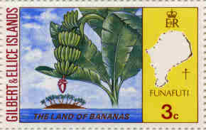 1972 Gilbert and Ellice Islands stamp
Funafuti is the capital of Tuvalu. It is a true atoll that consists of 30 islands, or motu, as called by the Tuvaluans, surrounding a lagoon 20 kilometres north to south by 11 kilometres east to west. The total land area consists of only 2.79 sq. kilometres.
Funafuti is often described as looking like a human head when viewed from space, with most of the land area appearing at the "back" of the head, or the eastern side of the lagoon. The lagoon at the narrow "neck" area is very shallow, and the surrounding islets are known for their unspoiled beauty and sandy beaches.
In 1897, Sir T. W. Edgeworth David, a Welsh-born Australian geologist drilled to a depth of 200 metres at Funafuti Atoll in an effort to verify Darwin's theory of the formation of coral atolls. Whereas his results supported Darwin's ideas, they were short of absolute proof. The main bore hole, called David's Drill, still can be seen today.
The largest island of Funafuti is Fogafale on the eastern side of the atoll. It is permanently connected to the island directly to the north, Tegako, by a concrete causeway, initially built by the Americans in during World War II. The runway on Fogafale was also built buy the Americans during the war. War relics can still be seen around the lagoon and other parts of the island. There is a burried bunker on Tepuka, which was an American wartime communications outpost.
The deep sea warf on the lagoon side of north Fogafale was completed on October 28, 1981. Before that, cargo to Funafuti had to be unloaded via boat or barge.
There is a shipwreck on the lagoon side just north of the warf, the Van Camp No. 1, which was blown ashore by Hurricane Bebe in 1972.
One of the smallest islands, Tepuka Sailivili, had all its vegetation and most of its sand washed away by Cyclone Meli in 1997.
The lagoon, which has several deep natural passages to the ocean, is known a Te Namo by the Tuvaluans. A conservation area called Kogatapu groups six of the uninhabited islands on the western side.
There are nine main villages on Funafuti, seven on Fogafale, and one each on Amatuku and Funafala. However, Fogafale is so densely populated it appears as one big sprawl. Most of the government offices are located in Vaiaku, including the main government building, the largest structure on the island. The population of Funafuti is 4,492 according to the 2002 census.
The largest man-made structure on Funafuti is the Tuvalu Government Building in Vaiaku, completed in 2004.
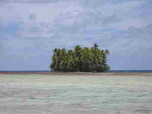 Tefota, 2005. (c) Brian Cannon
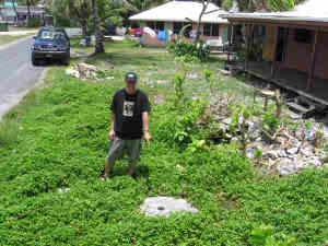 David's Drill, Fogafale, 2005. (c) Brian Cannon
The motu names are as follows:
- Amatuku
This island is about 1 kilometer long and a maximum 200 meters wide. Being the home of the Tuvalu Maritime Training Institute (TMTI), it has very favourable conditions; an independent power supply of that on Fogafale, telephone communications, daily access to the facilities on Fongafale, and a pleasant well vegetated setting. However, as with Fogafale, there is water rationing at times. The maximum population is about 65. Tuvaluan men are trained at the TMTI to become merchant seamen, to enable them to seek employment aboard foreign vessels. The school opened in 1979. Money sent home by seamen is a major source of revenue for Tuvalu. Approximately 43% of the male population of working age in Tuvalu are employed as seafarers. There are approximately 12 TMTI professional and support staff plus family members. The Institute accomodates up to 40 trainees per session, which lasts about 12 months. The oldest building in Tuvalu is on Amatuku, a thatched roof house with original coral rock walls. It was built in 1904 by the London Missionary Society as a school, and now is a heritage site. Construction of a renewable energy project began in early 2007 on Amatuku. It was instigated by Alofa Tuvalu, a French/Tuvaluan Non-Government Organization (NGO). Biogas digester units were to be installed, using human and pig waste to great power. Further plans include copra biodiesel, gasification from organic waste, a small windmill, thermal solar, PV systems, solar streetlights and compost
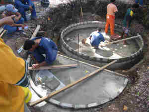 Installing biodigesters. (c) Christopher Horner, 2007
 Swimming off Amatuku, 2007. (c) Lomi Paeniu
Avalau
Falaoigo
Falefatu
Fatato ...more
Fogafale
Fuafatu
Fuagea
Fualefeke
Fualopa
Funafala
Funagogo (or Papaelise or Papa Elise) ...more
Funamanu
Luamotu
Mateiko
Motugie
Motuloa
Mulitefala
Paava
Teafuafou
Teafualiku
Tefala
Tefota
Telele
Tegako (now joined with Fogafale)
Tegasu
Tepuka
Tepuka Savilivili (vegetation washed away)
Tutaga
Vasafua
Disclaimer
This is not the official site of this country. Most of the information in this site were taken from the U.S. Department of State, The Central Intelligence Agency, The United Nations, [1],[2], [3], [4], [5],[6], [7], [8], [9], [10], [11], [12], [13], [14],[15], [16], [17], [18], [19], [20], [21], [22], [23], [24],[25], [26], [27], [28], [29], [30],[31], [32], [33], [34], and the [35].
Other sources of information will be mentioned as they are posted.
