LOG IN. UPLOAD PICTURES.
The Philippines has Zambo Mart to help propagate the Chavacano Language.
Difference between revisions of "Atoll, Marshall Islands"
(Created page with "'''Atoll, Marshall Islands''' '''Bikini''' File:Bravo.jpg<br> Bravo<br> ''cryogenic equipment. Detonated on March 1, 1954, at Bikini, another atoll in the Marshall I...") |
|||
| Line 3: | Line 3: | ||
'''Bikini''' | '''Bikini''' | ||
[[File: | [[File:Bravo1.jpg]]<br> | ||
Bravo<br> | Bravo<br> | ||
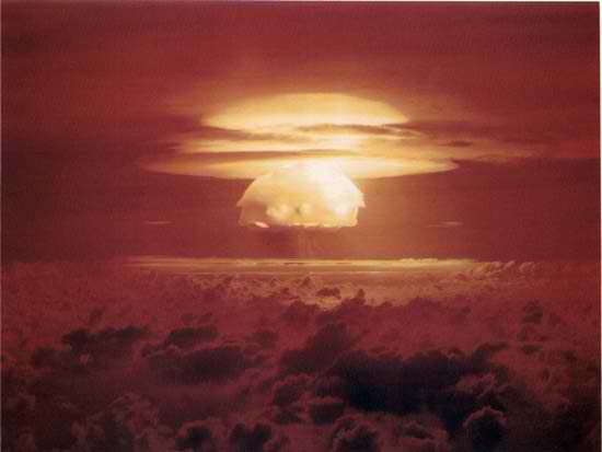
''cryogenic equipment. Detonated on March 1, 1954, at Bikini, another atoll in the Marshall Islands, the Bravo bomb produced a 15-megaton explosion—three times the expected yield. The large blast produced considerable unexpected radiation, which resulted in widespread contamination that forced the U.S. government to make restitution to various injured parties.''<br> | ''cryogenic equipment. Detonated on March 1, 1954, at Bikini, another atoll in the Marshall Islands, the Bravo bomb produced a 15-megaton explosion—three times the expected yield. The large blast produced considerable unexpected radiation, which resulted in widespread contamination that forced the U.S. government to make restitution to various injured parties.''<br> | ||
Latest revision as of 09:20, 20 August 2015
Atoll, Marshall Islands
Bikini

Bravo
cryogenic equipment. Detonated on March 1, 1954, at Bikini, another atoll in the Marshall Islands, the Bravo bomb produced a 15-megaton explosion—three times the expected yield. The large blast produced considerable unexpected radiation, which resulted in widespread contamination that forced the U.S. government to make restitution to various injured parties.
Bikini,
Castle, Operation: view of explosion during Bravo test of Operation Castle, March 1, 1954 [Credit: Stock footage courtesy The WPA Film Library]an atoll in the Ralik (western) chain of the Marshall Islands in the central Pacific Ocean. The atoll was used for peacetime atomic explosions conducted for experimental purposes by the United States between 1946 and 1958.
Lying north of the Equator, Bikini is 225 miles (360 km) northwest of Kwajalein and 190 miles (305 km) east of Enewetak Atoll. It consists of a ring of about 20 small coral islands whose average elevation is only some 7 feet (2.1 metres) above low tide level. The area of the group amounts to little more than 2 square miles (5 square km) of dry land, distributed about the edges of an oval lagoon 25 miles (40 km) long and 15 miles (24 km) wide. The largest islands are Bikini and Enyu (or Eneu). The atoll was known before World War II as Escholtz Atoll. It was administered by the United States from 1947 as part of the U.S. Trust Territory of the Pacific Islands under a United Nations trusteeship until it became part of the Republic of the Marshall Islands in 1979.
After Japan had been driven from the Marshall Islands in 1944, the islands and atolls, Bikini among them, came under the administration of the U.S. Navy. In 1946 Bikini became the site of Operation Crossroads, a vast military-scientific experiment to determine the impact of atomic bombs on naval vessels. The tests made it necessary to first relocate the atoll’s 166 native Micronesians to Rongerik and then to Kili Island, about 500 miles (800 km) southeast of Bikini. The world’s first peacetime atomic-weapons test was conducted at Bikini on July 1, 1946. A 20-kiloton atomic bomb was dropped from an airplane and exploded in the air over a fleet of about 80 obsolete World War II naval vessels, among them battleships and aircraft carriers, all of them unmanned. The second test, on July 25, was the world’s first underwater atomic explosion; it raised an enormous column of radioactive water that sank nine ships. Further tests, some of them thermonuclear, were conducted from 1954 to 1958, when Bikini, together with Enewetak Atoll, constituted the Pacific Proving Ground of the United States Atomic Energy Commission. In 1956 Bikini was the test site of the first hydrogen bomb dropped by a U.S. airplane.
The atoll suffered serious radioactive contamination from these tests. In 1969 the U.S. government began work on a long-range project to reclaim the land and, ultimately, to repatriate the Bikinian population. Some native islanders began returning to Bikini in the late 1960s, but they had to be moved back to Kili in 1978 when it became clear that radioactivity levels at Bikini were still dangerously high. In 1985, in response to a lawsuit filed by Bikini islanders, the U.S. government agreed to fund a cleanup of the island chain. Work began in 1991, and the first cleanup project was completed in 1998. However, radiation levels were still considered too high to allow resettlement, although they were deemed low enough to permit tourism on the atoll. In 1996 it was opened for scuba diving among the lagoon’s sunken warships, and sport fishing began two years later.
Majuro

Majuro
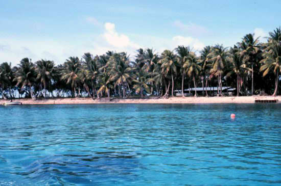
Majuro, Marshall Islands.
Majuro [Credit: Dr. James P. McVey/National Oceanic Atmospheric Administration Sea Grant Program]atoll in the Ratak (eastern) chain of the Marshall Islands and capital of the Republic of the Marshall Islands, in the western Pacific Ocean. The atoll comprises 64 islets on an elliptically shaped reef 25 miles (40 km) long and has a total land area of 4 square miles (10 square km). Majuro has the largest population of any atoll or island in the Marshall Islands. The atoll’s main settlement, which is situated on three islands connected by landfills—Dalap, Uliga, and Darrit—serves as the capital of the republic. The atoll has port facilities and an airport. Pop. (2004 est.) 20,800.
Jaluit Atoll
Jaluit Atoll, coral formation in the Ralik (western) chain of the Republic of the Marshall Islands, situated in the west-central Pacific Ocean. Jabor is the chief settlement. The atoll has a total land area of 4.4 square miles (11.4 square km) and a lagoon that is easily accessible and provides a good anchorage. The first missionaries to the Marshall Islands landed on Jaluit in 1857. The atoll was also the site (1885) of Germany’s formal declaration of a protectorate over the islands. Chosen as an administrative centre by Germany, it continued as such under the Japanese. Heavily fortified by the Japanese, Jaluit was devastated by U.S. bombing in World War II. Copra is exported and fishing is important. Pop. (1999) 1,669.
Enewetak Enewetak, also spelled Eniwetok, atoll, northwestern end of the Ralik chain, Republic of the Marshall Islands, in the western Pacific Ocean. Circular in shape (50 miles [80 km] in circumference), it comprises 40 islets around a lagoon 23 miles (37 km) in diameter. During World War II it was captured from the Japanese by U.S. forces (February 1944), and its fine anchorage was made into a naval base. Its inhabitants were evacuated to other atolls after it was designated, with Bikini atoll, a testing ground for atomic weapons. Tests were held in 1948, 1951, 1952, 1954, and 1956. In 1980, after the island’s contaminated topsoil was removed, Enewetak was declared decontaminated, and its people were given an opportunity to return. Their first crops grown were found to be too badly contaminated, and, as at Bikini atoll, the people had to be removed again. Pop. (latest est.) 1,100.
Abaiang Atoll
Abaiang Atoll, also spelled Apaiang, also called Apia, formerly Charlotte Island , coral atoll of the Gilbert Islands, part of Kiribati, in the west-central Pacific Ocean. Comprising six islets in the northern Gilberts, the atoll has a lagoon (16 miles by 5 miles [26 km by 8 km]) that provides sheltered anchorage. The islets of Abaiang are Teirio, Nuotaea, Nanikirata, Twin Tree, Ribona, and Iku. Its European discoverer, Capt. Thomas Gilbert (1788), named it Matthew’s Island for the owner of his ship, the Charlotte. He called the lagoon Charlotte Bay and the main islet Point Charlotte. Subsequent errors in identification led to the island’s being known as Charlotte Island. The area’s first influential missionary, the American Hiram Bingham, arrived there in 1857. The atoll, occupied by the Japanese in 1941–43, was subsequently used by Allied forces as a base for attacking the Marshall Islands. The administrative centre and main village is Tuarabu. Copra is exported. Total land area 7 square miles (18 square km). Pop. (2005 prelim.) 5,502.