File:Zimbabwe map.gif
Revision as of 06:01, 20 May 2009 by Maletsky (talk | contribs) (Geography of the Republic of Zimbabwe Area: 390,580 sq. km. (150,760 sq. mi.), slightly larger than Montana. Cities: Capital--Harare (pronounced Ha-RAR-e), pop. 1.5 million. Other towns--Bulawayo, Chitungwiza, Mutare, Gweru, Kwekwe, Masvingo, Marondera. T)
Zimbabwe_map.gif (344 × 368 pixels, file size: 13 KB, MIME type: image/gif)
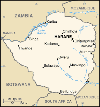
Geography of the Republic of Zimbabwe Area: 390,580 sq. km. (150,760 sq. mi.), slightly larger than Montana. Cities: Capital--Harare (pronounced Ha-RAR-e), pop. 1.5 million. Other towns--Bulawayo, Chitungwiza, Mutare, Gweru, Kwekwe, Masvingo, Marondera. Terrain: Desert and savanna. Climate: Mostly subtropical.
File history
Click on a date/time to view the file as it appeared at that time.
| Date/Time | Thumbnail | Dimensions | User | Comment | |
|---|---|---|---|---|---|
| current | 06:01, 20 May 2009 |  | 344 × 368 (13 KB) | Maletsky (talk | contribs) | Geography of the Republic of Zimbabwe Area: 390,580 sq. km. (150,760 sq. mi.), slightly larger than Montana. Cities: Capital--Harare (pronounced Ha-RAR-e), pop. 1.5 million. Other towns--Bulawayo, Chitungwiza, Mutare, Gweru, Kwekwe, Masvingo, Marondera. T |
You cannot overwrite this file.
File usage
The following 3 pages use this file:
