 Location of Andorra within the continent of Europe | |||
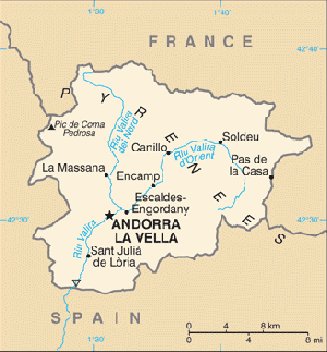
 Map of Andorra | |||
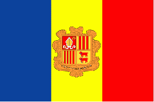
 Flag Description of Andorra:The Andorra flag was officially adopted in 1866. The flag features three equal vertical bands of blue, yellow, and red with the national coat of arms centered in the yellow band. Those colors are said to represent Andorra'a independence from both Franc.. |
|||
| |||
Background of Andorra
Andorrans live in seven valleys that form Andorra's political districts. Andorrans are a minority in their own country; they make up only approximately 37% of the population or about 31,500 native Andorrans. Spanish, French, and Portuguese residents make up the other 63% of the population.
People of Andorra
Andorrans live in seven valleys that form Andorra's political districts between France and northeast Spain. Andorrans are a minority in their own country; Spanish, French, and Portuguese citizens make up 64.01% of the population.
The national language is Catalan, a romance language related to the Provençal group. French and Spanish also are spoken.
Education law requires school attendance for children up to age 16. A system of French, Spanish, and Andorran public schools provide education up to the secondary level. Schools are built and maintained by Andorran authorities, but teachers are paid for the most part by France or Spain. About 50% of Andorran children attend the French primary schools; the rest attend Spanish or Andorran schools. Andorran schools follow the Spanish curriculum, and their diplomas are recognized by the Spanish education system. In July 1997, the University of Andorra was established. Due to its small student body, the University of Andorra is unable to develop a full academic program, and it serves principally as a center for virtual studies, connected to Spanish and French universities. There are two graduate schools in Andorra--the Nursing School and the School of Computer Science.
Geography of Andorra
- Area: total: 468 sq km,land: 468 sq km, water: 0 sq km
- Area - comparative: 2.5 times the size of Washington, DC
- Land boundaries: total: 118 km
- border countries: France 55 km, Spain 63 km
- Environment - current issues: deforestation; overgrazing of mountain meadows contributes to soil erosion; air pollution; wastewater treatment and solid waste disposal
- Location Southwestern Europe, Pyrenees mountains, on the border between France and Spain
- Geographic coordinates: 42 30 N, 1 30 E
- Coastline: 0 km (landlocked)
- Maritime claims: none (landlocked)
- Climate: temperate; snowy, cold winters and warm, dry summers
- Terrain: rugged mountains dissected by narrow valleys
- Elevation extremes: lowest point: Riu Runer 840 m
highest point: Pic de Coma Pedrosa 2,946 m
- Natural resources: hydropower, mineral water, timber, iron ore, lead
- Land use: arable land: 5.32%, permanent crops: 0%, other: 94.68% (2011)
- Natural hazards: avalanches
- Map references: Europe
- Environment - current issues: deforestation; overgrazing of mountain meadows contributes to soil erosion; air pollution; wastewater treatment and solid waste disposal
- Environment - international agreements: party to: Biodiversity, Desertification, Hazardous Wastes, Ozone Layer Protection
signed, but not ratified: none of the selected agreements
Disclaimer
This is not the official site of this country. Most of the information in this site were taken from the U.S. Department of State, The Central Intelligence Agency, The United Nations, [1],[2], [3], [4], [5],[6], [7], [8], [9], [10], [11], [12], [13], [14],[15], [16], [17], [18], [19], [20], [21], [22], [23], [24],[25], [26], [27], [28], [29], [30],[31], [32], [33], [34], and the [35].
Other sources of information will be mentioned as they are posted.