LOG IN. UPLOAD PICTURES.
The Philippines has Zambo Mart to help propagate the Chavacano Language.
Niger
Abalak | Agadez | Aguié | Arlit | Birni | Birni | Dakoro | Diffa | Dogondoutchi | Dosso | Filingué | Gaya | Gouré | Guidan | Illéla | Kollo | Madaoua | Magaria | Maïné-Soroa | Maradi | Matameye | Mirria | Nguigmi | Niamey | Say | Tahoua | Tânout | Tchirozérine | Téra | Tessaoua | Tillabéri | Zinder
|
|
THE NIGER COAT OF ARMS
| |||
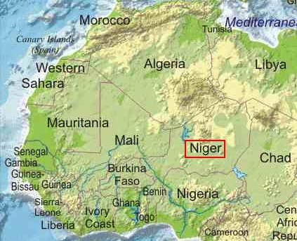
_-_NER_-_UNOCHA.svg) Location of Niger within the continent of Africa | |||
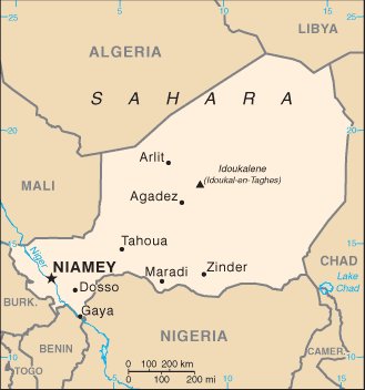
 Map of Niger | |||
 Flag Description of Niger:The Niger flag was officially adopted on November 23, 1959. The centered orange circle is symbolic of the sun. The orange stripe represents the savannah grasslands, white the Niger River, and green represents the country's rainforests. | |||
|
Official name République du Niger (Republic of Niger)
Form of government republic with one legislative house (National Assembly [113])1
Head of state President: Mahamadou Issoufou1
Head of government Prime Minister: Brigi Rafini
Capital Niamey
Official language French
Official religion none
Monetary unit CFA franc (CFAF)
Population (2014 est.) 18,535,000COLLAPSE
Total area (sq mi) 489,200
Total area (sq km) 1,267,000
Urban-rural population
- Urban: (2012) 21.7%
- Rural: (2012) 78.3%
Life expectancy at birth
- Male: (2012) 52.8 years
- Female: (2012) 55.1 years
Literacy: percentage of population age 15 and over literate
- Male: (2007–2008) 42.8%
- Female: (2007–2008) 17.1%
GNI per capita (U.S.$) (2013) 410
1Constitutional transition to civilian rule took place on April 7, 2011.
About Niger
Niger, officially Republic of Niger, French République du Niger, landlocked western African country. It is bounded on the northwest by Algeria, on the northeast by Libya, on the east by Chad, on the south by Nigeria and Benin, and on the west by Burkina Faso and Mali. The capital is Niamey. The country takes its name from the Niger River, which flows through the southwestern part of its territory. The name Niger derives in turn from the phrase gher n-gheren, meaning “river among rivers,” in the Tamashek language.
GEOGRAPHY OF NIGER
- Area: 1,267,000 sq. km (490,000 sq. mi.); about three times the size of California.
- Cities: Capital--Niamey (pop. approx. 1 million).
- Other cities--Tahoua, Konni, Maradi, Zinder, Diffa, Dosso, Arlit, and Agadez.
- Terrain: About two-thirds desert and mountains, one-third savanna.
- Climate: Hot, dry, and dusty. Rainy season June - September.

The Land
Relief
Niger extends for about 750 miles (1,200 kilometres) from north to south and about 930 miles from east to west. It tends to monotony in its features, is intersected by numerous depressions, and is dominated by arid highlands in the north. Rainfall increases as one proceeds southward so that the country divides naturally into three distinct zones—a desert zone in the north; an intermediate zone, where nomadic pastoralists raise cattle, in the centre; and a cultivated zone in the south. It is in this southern zone that the greater part of the population, both nomadic and settled, is concentrated.
The highlands of the north are cut by valleys (kori) of the Aïr Massif, which is an extension of the Ahaggar (Hoggar) Mountains of Algeria, and consists of a range running north to south in the centre of Niger, with individual mountain masses forming separate “islands”: from north to south these are Tazerzaït, where Mount Gréboun reaches an altitude of 6,379 feet (1,944 metres); Tamgak; Takolokouzet; Angornakouer; Bagzane; and Tarouadji. To the northeast is a series of high plateaus, which form a bridge between the Ahaggar Mountains of Algeria and the Tibesti Mountains of Chad. From west to east these are the plateaus of Djado, Mangueni, and Tchigaï.
The sandy regions of the Nigerian Sahara extend to either side of the Aïr. To the west the Talak region includes the Tamesna area in the north (where fossil valleys are filled with moving sand dunes) and the Azaoua area in the south. East of the Aïr is the Ténéré region, covered partly by an expanse of sand called an erg, partly by a stony plain called a reg.
The plateaus of the south, which form a belt about 900 miles long, may be divided into three regions. To the west is the Djerma Ganda region. Its large valleys are filled with sand, while dallol (fossilized valleys of rivers that formed tributaries of the Niger in ancient times) descend from the Aïr and the Iforas Massif of neighbouring Mali. The central region consists of the rocky Adar Doutchi and Majia areas; it is the region of the gulbi (dried-up valleys of former tributaries of the Sokoto River) and the Tegama—a tableland of sandstone, ending, toward the Aïr, at the Tiguidit scarp. To the east the underlying rock reappears in the Damagarim, Mounio, and Koutous regions, to the north of which is the region of Damergou, consisting of clays. In the Manga region, in the east, traces of ancient watercourses appear on the sandy plain.
Drainage and soils
It is convenient to make a distinction between the ancient hydrographic system, which allowed agriculturalists, fishermen, and pastoralists to live in the Aïr region about 5,000 or 6,000 years ago, and the present simple system, which forms the basis of the marked difference between the northern and southern parts of the country. The present system includes to the west the Niger River basin and to the east the basin of Lake Chad; between the two occur vestiges of the older system, such as the dallol and the gulbi.
To the west the Niger River crosses about 350 miles of Niger’s territory. Because of the change in river flow, which occurs because of the dispersal of its waters in its interior delta region in Mali, it is only in January and February that it flows past Niamey in flood. At other times the river is fed by certain temporary watercourses that flow in from the right bank. These are the Gorouol, the Dargol, the Sirba, the Goroubi, the Djamangou, the Tapoa, and the Mékrou; the last two flow through the “W” National Park (so called because the Niger flows through the area in the form of a W). On the left bank, proceeding eastward, appear the dallol, the vestiges of the older watercourses. Generally running from north to south, they constitute zones of dampness, although a few still contain waters that flow toward the Niger. The best known are the Bosso, the Foga, and the Maouri wadis. Other vestiges consist of the kori, which run down from the Aïr and from former tributaries that had their sources in the Iforas Massif, and which flowed to a confluence at what is now the Ti-m-merhsoï Wadi. No waters flow through the kori now, but water is still to be found beneath their sands. Other remnants of the old system are formed by the gulbi, through which water still flows annually, occasionally causing damage.
To the east is situated the basin of Lake Chad, a large, shallow lake, which at its highest contemporary level has an area of approximately 9,650 square miles; of this, Niger possesses about 1,100 square miles. Its extent is considerably reduced during the dry season. The Komadougou Yobé River, which flows into Lake Chad from the west, forms part of the frontier between Niger and Nigeria. Its water level, which begins to rise in August, from January to May consists only of some stagnant pools.
In addition to the drainage system described, it may be noted that rainwater collects in several basins, so that some permanent lakes or pools also exist; these are found at Keïta and Adouna in the Adar Doutchi region, at Madaroumfa in the Maradi gulbi, and at Guidimouni to the east of Zinder. The water table in some areas can also be tapped to produce artesian wells.
The soils fall into three natural regions. In the Saharan region in the north the soil is infertile, except in a few oases where water is found. In the region known as the Sahel, which forms a transitional zone between the Sahara and the region to the south, the soils are thin and white, being covered with salty deposits resulting from intense evaporation that forms an infertile surface crust. The third region (in the south) is cultivated. In this area the soils are associated with extensive dunes or uplands or with basins or depressions. Some of the soils in the latter, such as those in the Niger basin and in the gulbi, are rich. Black soils occur in the Kolo basin. Throughout the region, however, and above all on the plateaus, less fertile lateritic (leached iron-bearing) soils occur.
Climate
Niger extends southward from the tropic of Cancer, and the northern two-thirds of its territory lies in dry tropical desert. In the southern part of the country the climate is of the type known as Sahelian, which is characterized by a single, short rainy season. In January and February the continental equivalent of the northeast trade winds, the harmattan, blows southwestward from the Sahara toward the equator. Typically dust-laden, dry, and desiccating, the harmattan hinders normal living conditions on the southern fringe of the desert. From April to May the southern trade winds blowing from the Atlantic reach the equator and are diverted toward the Sahara where they meet with the harmattan—an encounter that results in violent line squalls and that signals the beginning of the rainy season. The rains last from one to four months, according to the latitude; August is the rainy month everywhere except in the far north, where the rainfall is unpredictable.
Niger lies in one of the hottest regions of the world. Temperatures rise from February to May and drop during the “winter” rainy season, rising again somewhat before falling to their annual minimum averages in December or January. During May (the hottest month), afternoon temperatures are high everywhere, ranging from a low of about 108° F (42° C) at Nguigmi on Lake Chad to 113° F (45° C) at Bilma and Agadez, both in the northern desert. In January, afternoon temperatures average more than 90° F (mid-30s C) at most stations but at night may drop to freezing level in the desert. The daily range is greater in the desert north than in the south and is also more extreme during the dry season.
Rainfall varies according to location as well as season. The 10-inch isohyet (line on a map connecting points having equal rainfall) follows a line from near Tahoua to Gouré, in effect marking the northern limit of nomadic pastoral life, for the rainfall permits a sparse vegetation to grow. To the extreme south the 30-inch isohyet marks the southern limit of this zone, after which the southern agricultural zone begins. In the course of the same rainy season a most irregular spatial pattern of rainfall may occur, while from one year to another the total amount of rainfall may also vary; in addition, the rainy season itself may arrive early or late, thus jeopardizing crops.
Plant and animal life
The vegetation of the desert zone clusters around the oases; it includes the date palm and cultivated corn (maize). Animal life, which must be able to endure hunger and thirst, includes the dromedary.
In the Sahel zone, where the doum palm and the cram-cram (Cenchrus biflorus, a prickly grass) appear, the vegetation has a short life cycle and is principally used for grazing. Animal life includes the ostrich and the gazelle.
In the cultivated zone the vegetation includes acacia trees, doum palms, and palmyra palms, as well as baobabs. Wildlife, which has partially disappeared, includes antelope, elephants, and warthogs; giraffes are found in the Zarmaganda and Damergou regions, and hippopotamuses and crocodiles on the banks of the Niger. The extreme southwest is a savanna region where baobabs, kapok trees, and tamarind trees occur. Animal life is preserved in the “W” National Park, where antelope, lions, buffalo, hippopotamuses, and elephants may be seen.
Settlement patterns
The southern part of Niger’s territory is situated in the vast region of Africa known as the Sudan, in which, in former times, large political states arose, such as Ghana, Mali, and Songhai, as well as the Hausa states, the empire of Sokoto, and Bornu. The northern part of Niger remains the domain of the Tuareg. The country comprises a multitude of traditional regions, the names of which remain despite the establishment of contemporary administrative divisions. All these regions have a fluctuating political, economic, and geographic significance: the Hausa regions, for example, have been cut in two and divided between Niger and Nigeria. Most regions, moreover, have been and remain zones where contact takes place between different peoples—between the Hausa and the Tuareg in the Adar Doutchi region, for example; between the Tuareg and the Kanuri in the Damergou region; and between Hausa and Zarma (Zerma, Djerma) in the Aréoua area.
About one-fifth of the population live in towns. The rural population comprises nomads and sedentary peoples. There are some 10,000 villages, of which approximately half have only a few hundred inhabitants; there are practically no villages in the desert zone. Fulani (Peul) herdsmen, who breed horned cattle and oxen, and the Tuareg, who raise goats, sheep, and dromedaries, tend to travel over the northern region during the winter. They meet together to permit the cattle to lick the salty soil of the In Gall region during August and September but move southward during the dry season. Both Fulani and Tuareg live in tribal groups, in temporary or portable shelters, and gain their subsistence from their livestock. The Fulani subsist above all on milk in various forms; the Tuareg live on meat and dates.
Sedentary peoples, such as the Hausa, the Songhai-Zarma, and the Kanuri, who inhabit the Niger and Chad basins, live largely by agriculture. They raise millet, rice, corn, peanuts (groundnuts), and cotton. They also work as blacksmiths and shoemakers, while on the banks of Lake Chad and the Niger the Buduma and Sorko peoples are fishermen. Sedentary peoples live in dwellings that vary from those made of straw to those made of banco (hardened mud), although the Wogo people live in tents of delicate matting.
There is a tendency among the nomads to settle down, and the already sedentary peoples are expanding the lands under cultivation toward the north. Rural life, above all in its sedentary form, tends to slow its pace during the long dry season; it is at this time of year that migration to the towns or other countries occurs.
It was approximately in the 15th century that a few towns, such as Agadez or Zinder, were first established as halting places, or depots, on the trans-Saharan caravan routes. As commercial routes gradually developed on the coasts, however, these northern towns lost their former economic importance, while other centres, such as Birni Nkonni, and Tessaoua, declined in the course of the 19th century as a result of the colonial era.
There are four principal towns in Niger. Niamey, the political capital, has experienced rapid growth. It has a cosmopolitan character and a transient population. Its characteristic life varies between the European and African rural styles, including various intermediate steps, of which the life-style of the évolués (educated Africans) is the most distinctive. Zinder, for which the African name is Damagaram, is an older town than Niamey; a Hausa town, it was the capital of Niger until 1926 and has a number of skilled craftsmen, especially leatherworkers and dyers. The town has experienced some industrial growth and has close links with Nigeria. Maradi has developed rapidly. The town is situated in the heart of the peanut-growing region near the Nigerian frontier. Many European companies have established branches there; the town is particularly renowned for its red goats, the skins of which are exported to Europe and the Americas. Tahoua has grown up on the edge of the desert. There it forms a large livestock market, where pastoralists and farmers meet. All of the towns remain little more than modest administrative and commercial centres, but because of the discovery of uranium ore Agadez has experienced a spectacular growth.
DEMOGRAPHY OF NIGER
The People
- Nationality: Noun and Adjective--Nigerien(s).
- Population (2007 est.) 14,853,000.
- Annual growth rate (2005): 3.3%.
- Ethnic groups: Hausa 53%, Djerma (Zarma) 21%, Fulani 7%, Tuareg 11%, Beri Beri (Kanuri) 6%; Arab, Toubou, and Gourmantche 2%.
- Religions: Islam (99%); remainder traditional and Christian.
- Languages: French (official), Hausa, Djerma, Fulfulde, Kanuri, Tamachek, Toubou, Gourmantche, Arabic.
- Education: Years compulsory--6. Attendance--45% (men), 31% (women). Literacy (2005)--28.7% (15% for women).
- Health: Infant mortality rate--150/1,000. Life expectancy--54.5 yrs.
The largest ethnic groups in Niger are the Hausa, who also constitute the major ethnic group in northern Nigeria, and the Djerma-Songhai, who also are found in parts of Mali. Both groups, along with the Gourmantche, are sedentary farmers who live in the arable, southern tier of the country. The remainder of Nigeriens are nomadic or semi-nomadic livestock-raising peoples--Fulani, Tuareg, Kanuri, Arabs, and Toubou. With rapidly growing populations and the consequent competition for meager natural resources, lifestyles of agriculturalists and livestock herders are increasingly threatened.
Niger's high infant mortality rate is comparable to levels recorded in neighboring countries. However, the child mortality rate (deaths among children under age of 5) is particularly high (198 per 1,000) due to generally poor health conditions and inadequate nutrition for most of the country's children. Nonetheless, Niger's fertility rate (7.8 births/woman), is among the highest in the world, and is far higher than the sub-Saharan African average of 5.4. Two-thirds (66.7%) of the Nigerien population is under age 25. Primary school net enrollment rate is 49% for boys and 31% for girls. Additional education occurs through thousands of Koranic schools.
- Linguistic groups
The largest linguistic group is formed by the Hausa, whose language, also spoken in Nigeria, is one of the most important in western Africa. A large percentage of the inhabitants of Niger understand Hausa, which possesses an abundant literature that has been printed in Latin characters in Nigeria. Songhai is the second most important language; it is also spoken in Mali, in northern Burkina Faso, and in northern Benin. In Niger itself it is divided into various dialects, such as Songhai proper, Zarma, and Dendi. The language of the Fulani is Fula; in Niger it has two dialects, eastern and western, the demarcation line between them running through the Boboye district. Tamashek is the language of the Tuareg, who often call themselves the Kel Tamagheq, or Tamashek speakers. The language is also spoken in Algeria and Mali and possesses its own writing, called tifinagh, which is in widespread use. Kanuri is spoken not only in Niger but also in Cameroon and Nigeria; the tongue is called Beriberi by the Hausa. While these five languages are the principal ones spoken in Niger, there is also an important Teda linguistic group in the Tibesti region. In addition, many of the peoples of Niger speak Arabic, and a still larger number read and write in that language; Agadez possesses one of the oldest Arabic schools in Africa. The use of the Arabic alphabet resulted in Fula and Hausa becoming written languages; the script is called ajami; a search for more old manuscripts in ajami is being conducted.
By using Hausa and Songhai, one may make oneself understood from one end of the country to the other. French, however, remains the official language, as well as the language of instruction, although it remains understood only by a small minority. English is taught as the principal foreign language in secondary schools.
- Ethnic groups
Ethnic groups correspond to the five linguistic groups already mentioned. The Hausa are the largest group, constituting more than half of the present population, though the majority of the Hausa people live in Nigeria. The Hausa occupy the centre of southern Niger as far as Dogondoutchi. The Songhai-Zarma are found in the southwest; the Songhai proper live along the Niger, where they are assimilating the Kurtey and Wogo peoples. The majority of the Songhai people as a whole, however, live in Mali. The Zarma live on the left bank of the Niger, remaining in close contact with the Mauri and Arewa peoples. The Fulani, who are dispersed throughout the country, are mostly nomadic; they are also found dispersed throughout western Africa. The Tuareg, also nomadic, are divided into three subgroups—the Iullemmiden of the Azaouak region in the west, the Asben (Kel Aïr) in the Aïr region, and the Itesen (Kel Geres) to the south and east of Aïr. The Tuareg people are also found in Algeria and in Mali. The Kanuri, who live to the east of Zinder, are divided into a number of subgroups—the Manga, the Dogara (Dagara), the Mober, the Buduma, and the Kanembu; they are also found living in Chad, Cameroon, and Nigeria. Apart from the nomadic Teda of the Tibesti region, who constitute an important minority, the remainder of the population consists of Arabs, black Africans from other countries, and Europeans, of whom the greater part are French.
- Religious groups
More than 95 percent of the population adhere to the Sunnite branch of Islām. Although the Annaawaa group of Hausa have always refused to accept Islām, as have a group of Fulani, the Wodaabe—who distinguish themselves from other Fulani for this reason—Islām remains the religion of the majority of both Hausa and Fulani. Christianity (Roman Catholicism and Protestantism) remains a religion of the towns, particularly of Niamey. There are several Christian missions in the Songhai and Arewa areas. Christianity is primarily a European religion, although it is also practiced by some black Africans from other countries. The traditional animist religions of the black Africans continue to manifest themselves in strength.
ECONOMY OF NIGER
- GDP (2006): $3.54 billion.
- Annual growth rate (2006): 4.8%.
- Per capita GDP (2006): $273.
- Avg. inflation rate (2006): 0.1%.
- Natural resources: Uranium, gold, oil, coal, iron, tin, and phosphates.
- Agriculture (27.9% of GDP): Products--millet, sorghum, cowpeas, peanuts, cotton, and rice.
- Industry (10.5% of GDP): Types--textiles, cement, soap, and beverages.
- Trade (2006): Exports (freight on board--f.o.b.)--$275 million. Types--uranium, livestock, gold, cowpeas, and onions.
- Major markets--France 34.8%, Nigeria 16.7%, Japan 13.3%, Spain 9.5%, U.S. 0.3%. Imports (f.o.b.)--$792 million. Types--consumer goods, petroleum, foodstuffs, and industrial products.
- Major suppliers--France 16.3%, China 13.1%, U.S. 7.1%, Nigeria 6.6%, Cote d'Ivoire 6.3%, India 4.7%, Japan 3.9%. --->ECONOMY OF NIGER|>>>Read More.<<<
The economy
The economic system is based upon planning but accords an important role to private enterprise. The three main policy objectives are the maintenance of national unity, the elevation of the living standards of the population, and the attainment of economic independence. The private sector of the economy consists partly of a multitude of small enterprises and partly of enterprises belonging to large French or international companies. The government, through the agency of the Development Bank of the Republic of Niger, which is funded partly by aid from abroad, has promoted the establishment of many companies, including real estate, road transport, air transport, and agricultural processing enterprises.
Niger is encouraging economic links between African countries. Apart from its membership in the Organization of African Unity, Niger is a member—together with Côte d’Ivoire, Benin, Burkina Faso, and Togo—of the Conseil de l’Entente, a regional cooperative group, as well as of the Organisation Commune Africaine et Mauricienne, another group of French-speaking African states.
- Resources
Salt is traditionally exploited in the Kaouar and Aïr regions, as well as in the dallol, and in the Manga district. Natron (hydrated sodium carbonate) is extracted locally. Cassiterite (an ore of tin) is mined at open workings in Aïr. Small quantities of gold are obtained by panning in the Sirba River. Limestone and an important deposit of gypsum have been located at Malbaza and in the Ader Doutchi and Majia region. Niger’s known reserves of uranium rank among the most important in the world. Apart from tungsten in the Aïr region, traces of copper, lignite (a brownish black coal), molybdenum, zinc, phosphates, and titanium have been found and are the subject of further prospection. A reserve of iron ore, with an iron content of about 50 percent, has been located in the Say region; and petroleum deposits have been discovered in the Lake Chad area.
The exploitation of plant resources has long been practiced but on a small scale. The doum palm and the palmyra palm provide wood for construction, while the palms of the Manga oasis produce dates. Small amounts of kapok (a silky down from the kapok tree, used for insulation, life jackets, and so forth) and of gum from the acacia gum tree are exported. Skins of ostriches, crocodiles, and snakes are used for making handicrafts that are exported to Europe. Fish from the Niger River and Lake Chad are exported southward to the coastal countries.
- Agriculture
Agriculture and agricultural products constitute the largest sector of Niger’s economy in terms of the number of persons employed and the percentage of gross national product (GNP). Millet and sorghum, the main food crops, are grown in the south, as are cassava and sugarcane. Rice is grown in the Niger River valley. Peanuts are the most important cash crop; other important crops include cotton and pulses.
Livestock is an important sector of the agricultural economy and is a major export. Cattle, sheep, and goats are raised for meat, milk, and hides.
Niger’s ability to remain self-sufficient in food and livestock production is closely linked to rainfall, and periods of drought have resulted in shortfalls requiring imports and food aid. To increase production and avoid cereal shortfalls, the government has invested in irrigation projects and an “off-season growing program” of small-scale production and irrigation operations.
- Industry
Niger is one of the world’s leading producers of uranium, which is mined at Arlit, Akouta, and Tassa. Extraction at the Arlit site is undertaken by the French-controlled Société des Mines de l’Aïr (SOMAIR). The second major mining concern, the Compagnie Minière d’Akouta (COMINAK), is owned partly by the government of Niger and partly by foreign interests. The Tassa mine opened in 1986 and is operated by SOMAIR. The uranium industry was seriously affected by the fall in uranium prices in the early 1980s. Development of additional sites is dependent upon an increase in world uranium prices.
Some manufacturing industries have been established, mostly at Niamey. They produce chemicals, food products, textiles, farm equipment, and metal furniture. There are many small craft industries in the principal towns.
Imported petroleum, supplemented by locally mined coal, is used to generate about half of Niger’s electricity, and the remaining amount is imported from Nigeria. The Office of Solar Energy has produced solar batteries, which are used in the country’s telecommunications network, and peanut shells have been experimentally used to supplement hydrocarbon fuels since 1968. Wood is the traditional domestic fuel.
- Transportation
While the economically active zone of Niger runs from east to west across the southern part of the country, the principal lines of communication run southward toward the coast. The two ports used by Niger—Cotonou in Benin and Lagos in Nigeria—are each more than 600 miles away, and Niger possesses no railroad. Traditional systems of transport and communication are still largely relied upon. These include camel caravans in the northern Sahel region, canoes on Lake Chad and the Niger, and individual travel on horseback or on foot. Only a small tonnage of goods is transported.
Trucks maintain transport communications between Maradi and Zinder in Niger and Kano in Nigeria, and between Niamey and Parakou in Benin. A road completed in 1981 connects the uranium-producing centres of Arlit and Akouta to Nigerian transport links. The principal west–east road axis enters the country from Gao in Mali, runs on the banks of the Niger as far as Niamey, and then continues eastward to Nguigmi on Lake Chad. From this central route, roads branch off southward. Toward the north, routes running via Tahoua and Tânout converge near Agadez, linking Niger to Algeria via Tamanrasset.
Air Niger is responsible for domestic air services linking the country’s airports, including those of Tahoua, Maradi, Zinder, Agadez, Diffa, and Arlit. Niamey has an international airport.
ADMINISTRATIVE AND SOCIAL CONDITION OF NIGER
- Type: Republic.
- Independence: August 3, 1960.
- Constitution: The constitution of December 26, 1992 was revised by national referendum on May 12, 1996 and again by referendum on July 18, 1999.
- Branches:
- Executive--president and prime minister. Legislative--unicameral National Assembly (113 MPs).
- Judicial--Constitutional Court, Supreme Court, Court of Appeals, High Court of Justice.
- Executive--president and prime minister. Legislative--unicameral National Assembly (113 MPs).
- Political parties: Seven are represented in the National Assembly.
- Suffrage: The constitution provides for universal suffrage for Nigeriens age 18 or older.
- Administrative subdivisions: Eight regions subdivided into 36 districts (departments) and 265 communes (local councils).

- Government
Under the constitution of 2010, Niger is a republic. The president, who serves as head of state, is elected to a five-year term by popular vote, with a limit of two terms. The president appoints the prime minister, who serves as the head of government. Legislative power is vested in the unicameral National Assembly; members are popularly elected and serve five-year terms. Niger’s judicial system comprises the High Court of Justice, the Supreme Court, the Constitutional Court, and the Courts of First Instance.
For administrative purposes, Niger is divided into one capital district—Niamey—and seven régions (regions)—Agadez, Diffa, Dosso, Maradi, Tahoua, Tillaberi, and Zinder—each of which is administered by a prefect. Each region is further divided into several districts, with each district led by a subprefect.
- Education
Education in Niger is free, but only a small proportion of children attend school. Primary and secondary schools and teacher-training colleges are the responsibility of the Ministry of National Education. Other ministries are responsible for technical education. Niger has one of the lowest adult literacy rates in western Africa, and literacy programs are conducted in the five principal African languages. Niamey has a university, and the Islamic University of Niger opened at Say in 1987.
- Health and welfare
The general state of health in the country is poor, and health care facilities are inadequate, especially in rural areas. The infant mortality rate, about 125 per 1,000 live births, is one of the highest in western Africa. Health services concentrate on the eradication of certain diseases in rural areas, as well as on health education. Campaigns have been successfully waged against sleeping sickness and meningitis, and vaccinations against smallpox and measles are administered. Other diseases, however, such as tuberculosis, malaria, and leprosy, remain endemic. Antituberculosis centres are located at Niamey, Zinder, and Tahoua. The lack of finances and shortage of trained personnel remain the principal obstacles to the improvement of health conditions.
CULTURE LIFE OF NIGER
Niger forms part of the vast Sahelian cultural region of western Africa. Although the influence of Islām is predominant, pre-Islāmic cultural traditions are also strong and omnipresent. Since independence, greater interest has been shown in the country’s cultural heritage, particularly with respect to traditional architecture, handicrafts, dances, and music. With the assistance of the United Nations Educational, Scientific and Cultural Organization, a regional centre for the collection of oral traditions has been established at Niamey. An institution prominent in cultural life is the National Museum at Niamey.
- Peoples of Niger
The Hausa are the largest group in Niger, making up around half the population. Other major groups include the Zarma-Songhai (comprising around one fifth of the population) and the Kanuri.
Nomadic or semi-nomadic groups include the Fulani and Tuareg peoples. These groups herd animals across the country, following ancient grazing routes. However, this traditional way of life is threatened by the recurrence of severe droughts in the region – see Climate & Agriculture.
The Tuaregs of Niger are part of a wider nomadic Tuareg community, which consists of groups living mainly across southern Algeria, eastern Mali and western Niger - see Tuaregs.
- Desert get-togethers
Nomadic groups often come together for special festivals or celebrations. One of the most famous is the Cure Salée – see Festivals.
- Dancing for a partner
Traditional costumes and dance form an integral part of the celebrations at many festivals.
Local dances include the Ruume (where dancers sing and clap in a circle) and the Gerewol, a ritual dance which also gives its name to a festival.
- A male beauty pageant
At Gerewol, young men of the Wodaabe (a nomadic Fulani group) paint their faces in dramatic fashion, creating black lips and eyes, and adorn themselves with shells and feathers to court the favours of young Wodaabe girls. Once the men have performed their dance, which they accompany with eye-rolling and grinning expressions, it’s the girls who get to choose which man they like best.
- Languages
French is the official language of government. However, most Nigeriens speak one of a number of local languages as their mother tongue. The West Chadic language of Hausa is the most common.
The five main local languages spoken in Niger are – Hausa, Songhai, Fula/Fulbe (spoken by the Fulani), Tamasheq/Tamajaq (spoken by the Tuareg) and Kanuri/Beri-Beri.
HISTORY OF NIGER
Considerable evidence indicates that about 600,000 years ago, humans inhabited what has since become the desolate Sahara of northern Niger. Long before the arrival of French influence and control in the area, Niger was an important economic crossroads, and the empires of Songhai, Mali, Gao, Kanem, and Bornu, as well as a number of Hausa states, claimed control over portions of the area.
During recent centuries, the nomadic Tuareg formed large confederations, pushed southward, and, siding with various Hausa states, clashed with the Fulani Empire of Sokoto, which had gained control of much of the Hausa territory in the late 18th century.
In the 19th century, contact with the West began when the first European explorers--notably Mungo Park (British) and Heinrich Barth (German)--explored the area searching for the mouth of the Niger River. Although French efforts at pacification began before 1900, dissident ethnic groups, especially the desert Tuareg, were not subdued until 1922, when Niger became a French colony.
Niger's colonial history and development parallel that of other French West African territories. France administered its West African colonies through a governor general at Dakar, Senegal, and governors in the individual territories, including Niger. In addition to conferring French citizenship on the inhabitants of the territories, the 1946 French constitution provided for decentralization of power and limited participation in political life for local advisory assemblies.
A further revision in the organization of overseas territories occurred with the passage of the Overseas Reform Act (Loi Cadre) of July 23, 1956, followed by reorganization measures enacted by the French Parliament early in 1957. In addition to removing voting inequalities, these laws provided for creation of governmental organs, assuring individual territories a large measure of self-government. After the establishment of the Fifth French Republic on December 4, 1958, Niger became an autonomous state within the French Community. Following full independence on August 3, 1960, however, membership was allowed to lapse.
For its first 14 years as an independent state, Niger was run by a single-party civilian regime under the presidency of Hamani Diori. In 1974, a combination of devastating drought and accusations of rampant corruption resulted in a military coup that overthrew the Diori regime. Lieutenant Colonel Seyni Kountche and a small group of military ruled the country until Kountche's death in 1987. He was succeeded by his Chief of Staff, Brigadier General Ali Saibou, who released political prisoners, liberalized some of Niger's laws and policies, and promulgated a new constitution. However, President Saibou's efforts to control political reforms failed in the face of union and student demands to institute a multi-party democratic system. The Saibou regime acquiesced to these demands by the end of 1990. New political parties and civic associations sprang up, and a national conference was convened in July 1991 to prepare the way for the adoption of a new constitution and the holding of free and fair elections. The debate was often contentious and accusatory, but under the leadership of Prof. Andre Salifou, the conference developed consensus on the modalities of a transition government. A transition government was installed in November 1991 to manage the affairs of state until the institutions of the Third Republic were put into place in April 1993. While the economy deteriorated over the course of the transition, certain accomplishments stand out, including the successful conduct of a constitutional referendum; the adoption of key legislation such as the electoral and rural codes; and the holding of several free, fair, and nonviolent nationwide elections. Freedom of the press flourished with the appearance of several new independent newspapers.
Rivalries within a ruling coalition elected in 1993 led to governmental paralysis, which provided Col. Ibrahim Bare Mainassara a rationale to overthrow the Third Republic and its President, Mahamane Ousmane, in January 1996. While leading a military authority that ran the government (Conseil de Salut National) during a 6-month transition period, Bare enlisted specialists to draft a new constitution for a Fourth Republic announced in May 1996. After dissolving the national electoral committee, Bare organized and won a flawed presidential election in July 1996 and his party won 90% of parliament seats in a flawed legislative election in November 1996. When his efforts to justify his coup and subsequent questionable elections failed to convince donors to restore multilateral and bilateral economic assistance, a desperate Bare ignored an international embargo against Libya and sought Libyan funds to aid Niger's economy. In repeated violations of basic civil liberties by the regime, opposition leaders were imprisoned; journalists often arrested, beaten, and deported by an unofficial militia composed of police and military; and independent media offices were looted and burned with impunity.
In the culmination of an initiative started under the 1991 national conference, however, the government signed peace accords in April 1995 with all Tuareg and Toubou groups that had been in rebellion since 1990, claiming they lacked attention and resources from the central government. The government agreed to absorb some former rebels into the military and, with French assistance, help others return to a productive civilian life.
In April 1999, Bare was overthrown and assassinated in a coup led by Maj. Daouda Mallam Wanke, who established a transitional National Reconciliation Council to oversee the drafting of a constitution for a Fifth Republic with a French style semi-presidential system. In votes that international observers found to be generally free and fair, the Nigerien electorate approved the new constitution in July 1999 and held legislative and presidential elections in October and November 1999. Heading a coalition of the National Movement for a Developing Society (MNSD) and the Democratic and Social Convention (CDS), Mamadou Tandja won the presidency.
In July 2004, Niger held municipal elections nationwide as part of its decentralization process. Some 3,700 people were elected to new local governments in 265 newly established communes. The ruling MNSD party won more positions than any other political party; however, opposition parties made significant gains.
In November and December 2004, Niger held presidential and legislative elections. Mamadou Tandja was elected to his second 5-year presidential term with 65% of the vote in an election that international observers called generally free and fair. This was the first presidential election with a democratically elected incumbent and a test to Niger's young democracy.
In the 2004 legislative elections, the National Movement for the Development of Society (MNSD), the Democratic and Socialist Convention (CDS), the Rally for Social Democracy (RSD), the Rally for Democracy and Progress (RDP), the Nigerien Alliance for Democracy and Progress (ANDP), and the Social Party for Nigerien Democracy (PSDN) coalition, which backed Tandja, won 88 of the 113 seats in the National Assembly.
A previously unknown group, the Mouvement des Nigeriens pour la Justice (MNJ), emerged in February 2007. The predominantly Tuareg group has issued a number of demands, mainly related to development in the north. It has attacked military and other facilities and laid landmines in the north. The resulting insecurity has devastated Niger's tourist industry and deterred investment in mining and oil. The government has labeled the MNJ criminals and traffickers, and refuses to negotiate with the group until it disarms.
GOVERNMENT AND POLITICAL CONDITIONS OF NIGER
Niger's new constitution was approved in July 1999. It restored the semi-presidential system of government of the December 1992 constitution (Third Republic) in which the president of the republic, elected by universal suffrage for a 5-year term, and a prime minister named by the president share executive power. As a reflection of Niger's increasing population, the unicameral legislature was expanded in 2004 to 113 deputies elected for a 5-year term under a proportional system of representation. Political parties must attain at least 5% of the vote in order to gain a seat in the legislature.
Niger's independent judicial system is composed of four higher courts--the Court of Appeals, the Supreme Court, the High Court of Justice, and the Constitutional Court. In January 2007, the National Assembly voted to divide the Supreme Court into three high courts--an Administrative Court, a Supreme Court of Justice, and an Audit Court.
The constitution also provides for the popular election of municipal and local officials, and the first-ever successful municipal elections took place July 24, 2004. The National Assembly passed in June 2002 a series of decentralization bills. As a first step, administrative powers have been distributed among 265 communes (local councils); in later stages, regions and departments will be established as decentralized entities. A new electoral code was adopted to reflect the decentralization context. The country is currently divided into 8 regions, which are subdivided into 36 districts (departments). The chief administrators in each region (Governor) and department (Prefect) are appointed by the government and function primarily as the local agents of the central authorities.
The current legislature elected in December 2004 contains seven political parties. President Mamadou Tandja was re-elected in December 2004 and reappointed Hama Amadou as Prime Minister. Mahamane Ousmane, the head of the CDS, was re-elected President of the National Assembly (parliament) by his peers. The new second term government of the Fifth Republic took office on December 30, 2004. In May 2007, Hama Amadou stepped down as Prime Minister following a vote of no confidence by the National Assembly related to allegations of his involvement in a corruption scandal, and President Tandja appointed Seini Oumarou Prime Minister as head of a new cabinet.
Principal Government Officials President and Chief of State--Mamadou Tandja Prime Minister--Seini Oumarou Minister of Foreign Affairs and Cooperation--Aichatou Mindaoudou Ambassador to the United States--Aminata Maiga Djibrilla Toure
Niger maintains an embassy in the United States at 2204 R Street, NW, Washington, DC 20008 (tel. 202-483-4224/25/26/27) and a permanent mission to the United Nations at 417 East 50th Street, New York, NY 10022 (tel. 212-421-3260).
Next Elections Scheduled Presidential elections--November/December 2009, two rounds; no date selected. Legislative elections--December 2009; no date selected. Local elections--Not scheduled, but expected in 2009. Last local election was in July 2004.
Foreign Aid in Niger
The most important donors in Niger are France, the European Union, the World Bank, the IMF, and UN agencies--UNDP, UNICEF, FAO, WFP, and UNFPA. Other donors include the United States, Belgium, Germany, Switzerland, Japan, China, Italy, Libya, Egypt, Morocco, Iran, Denmark, Canada, and Saudi Arabia. While the U.S. Agency for International Development (USAID) does not have a Mission in Niger, the United States is a major donor, contributing on average $30 million each year to Niger's development. In early 2008 Niger concluded an agreement for a $23 million Millennium Challenge Account threshold program. Niger is a key participant in the Trans-Saharan Counter-Terrorism program. Niger also benefits from the largest non-emergency PL 480 food assistance program in West Africa. Foreign aid represents 8.3% of Niger's GDP and over 40% of government revenues.
DEFENSE of Niger
The Niger Armed Forces total 12,000 personnel with approximately 3,700 gendarmes, 300 air force, and 8,000 army personnel. The air force has four transport aircraft. The armed forces include general staff and battalion task force organizations consisting of two paratroop units, four light armored units, and nine motorized infantry units located in Tahoua, Agadez, Dirkou, Zinder, Nguigmi, N'Gourti, and Madewela. In 1991, Niger sent a 400-man military contingent to join the American-led allied forces against Iraq during the Gulf War. Niger provides a battalion of peace-keeping forces to the UN Mission in Cote d'Ivoire.
Niger's defense budget is modest, accounting for about 1.6% of government expenditures. France provides the largest share of military assistance to Niger. Approximately 18 French military advisers are in Niger. Many Nigerien military personnel receive training in France, and the Nigerien Armed Forces are equipped mainly with materiel either given by or purchased in France. Morocco, Algeria, China, and Libya are also providing military assistance. A small U.S. foreign military assistance program was initiated in 1983. A U.S. Defense Attache office opened in June 1985 and assumed Security Assistance Office responsibilities in 1987. The office closed in 1996 following a coup d'etat. The U.S. Defense Attache office reopened in July 2000. The United States provided transportation and logistical assistance to Nigerien troops deployed to Cote d'Ivoire in 2003.
Additionally, the U.S. provided initial equipment training on vehicles and communications gear to a company of Nigerien soldiers as part of the Department of State Pan-Sahel Initiative. Military to military cooperation continues via the Trans Saharan Counter-Terrorism Partnership and other initiatives. EUCOM contributes funds for humanitarian assistance construction throughout the country. In 2007, a congressional waiver was granted which allows the Niger military to participate in the International Military Education and Training (IMET) program, managed by the Defense Attache Office. This program funded $170,000 in training in 2007.
FOREIGN RELATIONS
Niger pursues a moderate foreign policy and maintains friendly relations with the West and the Islamic world as well as nonaligned countries. It belongs to the United Nations and its main specialized agencies and in 1980-81 served on the UN Security Council. Niger maintains a special relationship with France and enjoys close relations with its West African neighbors. It is a charter member of the African Union and the West African Monetary Union and also belongs to the Niger River and Lake Chad Basin Commissions, the Economic Community of West African States, the Nonaligned Movement, and the Organization of the Islamic Conference.
U.S.-NIGERIEN RELATIONS
U.S. relations with Niger have generally been close and friendly since Niger attained independence. Although USAID does not have a Mission in Niger, $30 million in annual official aid is administered through American and local non-governmental organizations with programs addressing food security, health, local governance, youth training, girls' education, corruption control, and improving the business environment. The U.S. Peace Corps program in Niger started in 1962. It currently has about 130 volunteers in country and celebrated its 45th anniversary in Niger in September 2007.
Principal U.S. Officials
Ambassador--Bernadette M. Allen Deputy Chief of Mission--Eric Whitaker Defense Attache--vacant Joint Management Officer--Sonja Rix Economic/Commercial/Consular Officer--Karen Swaner Public Affairs Officer--Stephen J. Posivak Peace Corps Director--Mary Abrams USAID Country Program Manager--Mark Wentling
The U.S. Embassy in Niger is located on the Avenue des Ambassades. The telephone numbers for the embassy are (227) 20-72-26-61 through 65, and the fax number is (227) 20-73-31-67. The mailing address is B.P. 11201, Niamey.
TRAVEL AND BUSINESS INFORMATION
The U.S. Department of State's Consular Information Program advises Americans traveling and residing abroad through Country Specific Information, Travel Alerts, and Travel Warnings. Country Specific Information exists for all countries and includes information on entry and exit requirements, currency regulations, health conditions, safety and security, crime, political disturbances, and the addresses of the U.S. embassies and consulates abroad. Travel Alerts are issued to disseminate information quickly about terrorist threats and other relatively short-term conditions overseas that pose significant risks to the security of American travelers. Travel Warnings are issued when the State Department recommends that Americans avoid travel to a certain country because the situation is dangerous or unstable. For the latest security information, Americans living and traveling abroad should regularly monitor the Department's Bureau of Consular Affairs Internet web site at http://www.travel.state.gov, where the current Worldwide Caution, Travel Alerts, and Travel Warnings can be found. Consular Affairs Publications, which contain information on obtaining passports and planning a safe trip abroad, are also available at http://www.travel.state.gov. For additional information on international travel, see http://www.usa.gov/Citizen/Topics/Travel/International.shtml.
The Department of State encourages all U.S. citizens traveling or residing abroad to register via the State Department's travel registration website or at the nearest U.S. embassy or consulate abroad. Registration will make your presence and whereabouts known in case it is necessary to contact you in an emergency and will enable you to receive up-to-date information on security conditions.
Emergency information concerning Americans traveling abroad may be obtained by calling 1-888-407-4747 toll free in the U.S. and Canada or the regular toll line 1-202-501-4444 for callers outside the U.S. and Canada.
The National Passport Information Center (NPIC) is the U.S. Department of State's single, centralized public contact center for U.S. passport information. Telephone: 1-877-4-USA-PPT (1-877-487-2778); TDD/TTY: 1-888-874-7793. Passport information is available 24 hours, 7 days a week. You may speak with a representative Monday-Friday, 8 a.m. to 10 p.m., Eastern Time, excluding federal holidays.
Travelers can check the latest health information with the U.S. Centers for Disease Control and Prevention in Atlanta, Georgia. A hotline at 800-CDC-INFO (800-232-4636) and a web site at http://wwwn.cdc.gov/travel/default.aspx give the most recent health advisories, immunization recommendations or requirements, and advice on food and drinking water safety for regions and countries. The CDC publication "Health Information for International Travel" can be found at http://wwwn.cdc.gov/travel/contentYellowBook.aspx.
Further Electronic Information
Department of State Web Site. Available on the Internet at http://www.state.gov, the Department of State web site provides timely, global access to official U.S. foreign policy information, including Background Notes and daily press briefings along with the directory of key officers of Foreign Service posts and more. The Overseas Security Advisory Council (OSAC) provides security information and regional news that impact U.S. companies working abroad through its website http://www.osac.gov
Export.gov provides a portal to all export-related assistance and market information offered by the federal government and provides trade leads, free export counseling, help with the export process, and more.
STAT-USA/Internet, a service of the U.S. Department of Commerce, provides authoritative economic, business, and international trade information from the Federal government. The site includes current and historical trade-related releases, international market research, trade opportunities, and country analysis and provides access to the National Trade Data Bank.
Niger River
River, Africa
Niger basin [Credit: Encyclopædia Britannica, Inc.]principal river of western Africa. With a length of 2,600 miles (4,200 km), it is the third longest river in Africa, after the Nile and the Congo...>>>Read On<<<
Niger in 2004
Niger Area: 1,189,546 sq km (459,286 sq mi) Population (2004 est.): 11,679,000 Capital: Niamey Head of state and government: President Tandja Mamadou, assisted by Prime Minister Hama Amadou Niger ...>>>Read On<<<
Disclaimer
This is not the official site of this country. Most of the information in this site were taken from the U.S. Department of State, The Central Intelligence Agency, The United Nations, [1],[2], [3], [4], [5],[6], [7], [8], [9], [10], [11], [12], [13], [14],[15], [16], [17], [18], [19], [20], [21], [22], [23], [24],[25], [26], [27], [28], [29], [30],[31], [32], [33], [34], and the [35].
Other sources of information will be mentioned as they are posted.